"Thursday, Jan 11, 2024 - 04:20 PM
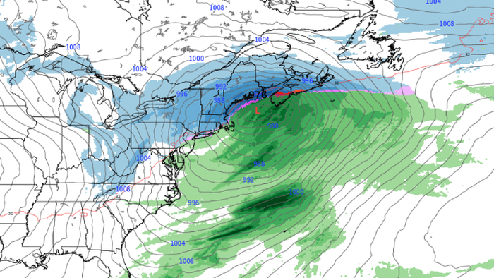
The weather forecast for next week paints an ominous picture for the Mid-Atlantic and Northeast, as Ryan Maue, a meteorologist and former NOAA chief scientist, is closely monitoring the development of a winter storm next Tuesday.
"Monitoring 7-day models for the development of a massive hurricane-force blizzard for the Northeast next Tuesday –'and then extremely cold Arctic air behind it,' Maue wrote on social media platform X.
Monitoring 7-day models for development of a massive hurricane-force blizzard for the Northeast next Tuesday -- and then extremely cold Arctic air behind it.
Big cities will probably avoid heavy snowfall (again) e.g. DC/NYC/Boston, but interior New England would get walloped. pic.twitter.com/d98GeJMKi6— Ryan Maue (@RyanMaue) January 10, 2024"
Maue said, 'Big cities will probably avoid heavy snowfall (again) e.g. DC/NYC/Boston, but interior New England would get walloped.'
For research/experimental reference, this is GraphCast-ECMWF 00z precipitation. Sorry, no snowfall with this model, but you can eyeball the 32°/35°F isotherms. pic.twitter.com/L99udB6pIl— Ryan Maue (@RyanMaue) January 10, 2024"
He said the parade of storms won't stop as the 'Arctic blast configuration means more Nor'easters. Assuming that stays in place for 10 days, then another winter storm.'
The parade of storms doesn't stop. The Arctic blast configuration means more Nor'easters. Assuming that stays in place in 10-days, then another winter storm.
I'd assume this pattern will break into the 3rd week of January, but who knows. pic.twitter.com/422H74PEWF— Ryan Maue (@RyanMaue) January 10, 2024"
In a separate report, private weather forecaster BAMWX provided clients this morning on X with a new long-range pattern analysis, echoing Maue's forecast for a big snow event for the Northeast next week (skip to the 3:30 minute mark).
1-10-24 Long Range Pattern Analysis. Extreme Cold & Active!
Video in order as followed!
-Extreme cold & active.
-Another storm next week & cold shot.
-MJO 4/5/6
-Mild risk ~Jan 24 to Feb 1 or so (up for debate).
-Cold/active pattern reloads into Feb.
View & share! #natgas… pic.twitter.com/PKhnI1WwIH— BAM Weather (BAMWX) (@bamwxcom) January 10, 2024"
All eyes are on next week as a parade of storms continues to batter the Mid-Atlantic and Northeast regions while a cold blast from Canada is expected."

